FROM Rt1:
Take Rt 1 north, pass Woodbridge Mall,
Take exit to Rt 35 North
Proceed 3-4 miles (pass K-Mart), after underneath bridge crossing 2nd light make
a right to West Inman ave (Mobil & Exxon Gas Station),
than make a left on 2nd Stop sign at New Brunswick ave,
2nd right will be Regina ave - field will be on your left.
FROM Garden State Parkway:
Take exit 131 to Rt 27 north,
take 4th light left at Saint George ave,
take 2nd light right to West Inman ave (Mobil & Exxon Gas Station),
than make a left on 2nd Stop sign at New Brunswick ave,
2nd right will be Regina ave - field will be on your left.

NJ Turnpike exit 9, take Rt.1 South, make right on College Farm Road. Drive for 0.5 mile.
Take Rt 1 South (from Cook College fields).
Continue for approx. 2-3 miles once you go over the bridge (Toyota/ Saturn dealership on the left).
Stay in the right lane you'll come to the traffic light.
Make a right (Cozzens lane). The road will go right and then left.
Go for approx 1/2 mile. There will be a traffic light.
The Sabella Park fields are on the right.
Pass the park and go further, you will see the Fire-station on your left.
Make a left turn right after the Fire-station and go to the end.
Make another left turn (Schmidt Lane) the fields will be on your left.
GSP North to Route 24 West (you must get on 78 east first and U Turn to go west, then that will go into 24 west) and take it to the Short Hills Mall.
Exit for Livingston/Kennedy Parkway.
Take Kennedy towards Livinston .
Cross So. Orange Ave. and Northfield Ave.
Turn left into the School at the Municipal Building.
The field is behind the school.
The field is a turf field, use molded or turf shoes no screw-ins please.
If you want to take 287 N to Route 10 East you will continue on 10 east to Livingston Ave and turn Right.
Go to the third traffic light and turn Right, the Police Station and Municipal Bldgs. will be on your Left.
Go 1/2 around the oval and the field is in the rear of the building.
From the GSPkwy South bound take exit 135; get onto circle and go left under GSPkwy overpass.
Once on other side, take the first exit from circle - Brant Ave (sign says: Rahway).
From the GSPkwy North bound take exit 135, and bear to the right onto Brant Ave.
Once on Brant Ave.... Go 0.2 miles on Brant Ave. till it dead ends into
Westfield Ave at a stoplight.
Make a left onto Westfield Ave.
FYI - from Brant Ave., the park is only 0.7 miles down Westfield Ave. on the right hand side.
Go thru 1st stoplight. Next right is Kline Place (right turn only).
Shortly after Kline Place, Make right turn into Jr High School parking lot.
You will see soccer field in front (runs parallel and just to the right of Westfield Ave.)
Park in school parking lot.
If you get to a 2nd stoplight, Westfield Ave. & Madison Ave., you missed the entrance for the school parking lot.
1-a) Directions to Thomas A. Edison Park from Route 1 Southbound Traveling south on Route 1 pass Menlo Park Mall and Route 287, and exit at Bonhamtown/County Road 531 South (just after Metuchen exit) which merges onto Main Street going south towards Bonhamtown. Then continue following directions 2) below.
1-b) Directions to Thomas A. Edison Park from Route 1 Northbound Traveling north on Route 1 exit at Bonhamtown/County Road 531 South (shortly after BJ's and immediately before Route 287) which merges onto Main Street going south towards Bonhamtown. Then continue following directions 2) below.
2) About one mile ahead, Main St ends at a traffic light. Turn RIGHT onto Woodbridge Ave. Travel one mile (Middlesex County College will be on your left) to the third traffic light and turn LEFT onto Mill Road (the college campus will still be on your left). Continue about 1/2 mile (just past the traffic light) and turn LEFT into Thomas Edison Park (look for the "easy-to-miss" plaque designating the park entrance at ground level on your left). About 1/2 mile into park (past railroad tracks and police academy) turn LEFT at "Ball Fields" sign.
For fields #2 and #3 look for fields straight ahead and parking on your right. 1st field is #2 (full size), 2nd field is #3 (division 5 - small sided). For fields #1 and #4 look for next "Ball Fields" sign and turn LEFT again. A short distance ahead turn RIGHT. Field #1 (full size) is on your right, field #4 (division 5 - small sided) is on your left, and parking is straight ahead.
Directions can be found from the Bridgewater Soccer Association's website. Look for Crim Park.
(extracted from the above site):
FROM NORTH
Rt. 287 south to the Rt. 202/206 Exit (Somerville). Stay in right lane of exit ramp. As ramp merges with Rt. 202/206, make a quick right turn onto the Commons Way exit. At end of ramp turn left onto Commons Way. You will be going around the mall. Go to third light and turn left onto Prince Rogers Ave. Go to the first light at N. Bridge St. and make a left onto N. Bridge Street. Follow past the Green Knoll Fire Station, still proceed until Mine Road. Make a right onto Mine Road. Take to the fork and bear right onto Crim Road. Take Crim Rd. up over the mountain, the Crim Elementary School will be on your left (over flow parking is here) the entrance to the park is on your right across from the school. DO NOT PARK ON THE LEFT HAND SIDE OF THE ENTRANCE INTO THE PARK. Use parking lot.
FROM WEST
Rt. 78 east to Rt. 287 south. Follow FROM NORTH directions above.
FROM WEST
Rt. 22 east to N. Bridge St. exit. Follow FROM SOUTH Rt. 202/206 directions above.
FROM EAST
Route 22 west. Follow FROM SOUTH Rt. 287 directions above.
Directions can be found from the website of the indoor field.
The Woodbridge Club is located on the right side of Main Street (take Woodbridge Ave East) after you cross the bridge over the Turnpike. From the Turnpike it's exit 10 (Rt 440 Rt 287, Metuchen exit), then Woodbridge Ave East (Woodbridge direction).
The address of the place (in case you want to check the directions on the Internet):
Club At Woodbridge
585 Main St, Woodbridge, NJ 07095
(732) 634-5000
Take 287 north
Take the US-22 W exit- exit number 14B
On Rt.22 W Take the US-202/US-206 South ramp towards FLEMINGTON/PRINCETON.
Take US-202 S towards FLEMINGTON/PRINCETON.
Travel about 2 miles.
Turn RIGHT onto MILLTOWN RD. after HOME DEPOT plaza and train overpass.
Field will be 0.5 mile on the left.
Take Parkway North till exit 135(Clark)
Bare right at the exit. Get on Brant ave.
Go 1 block till first traffic light and make left on Westfiled ave
Go past 1 traffic light and before 2nd traffic light(Madison ave)
The filed is on the right hand side. Pull in the school parking lot, our filed is the closest to school #1
The other landmark, is the field is right across Rahway Hospital
Website Phone: (908) 236-6355
Directions:
Take I-78 west to exit 20 A to Route 22 west, follow signs to the park.
Take I-78 east to exit 18 (Route 22 east), follow signs to the park.
MERCER COUNTY PARK (609)989-6530
Location: Mercer County Park is bounded by Old Trenton Road (Edinburg Rd.), Hughes Drive, Quakerbridge Road, Village Road West, North Post Road, Conover Road and South Post Road. Entrances to the Park are located on Hughes Drive, Edinburg Road and South Post Road.
DIRECTIONS:
FROM: North & South via Interstate 295:
Take 295 to exit 65A, Sloan Ave. East on Sloan Ave., after the first traffic light travel .7 mile to Paxson Ave. Turn left onto Paxson and proceed .9 mile to intersection of Hughes Dr. and entrance to Mercer County Park
FROM: South via US #1:
Cross Toll Bridge into New Jersey on US 1. Take first right past Quakerbridge Mall onto Quakerbridge Rd. Travel 2.2 miles and turn left onto Hughes Dr. Proceed on Hughes Dr. for ˝ mile to entrance of Mercer County Park on the left.
FROM: South via Route 130/206:
Follow Route 130 North to 526 in Robbinsville. Turn left at traffic light at Route 526 and right at the next light, ( still 526). From this point travel 3 miles to Route 535 ( Edinburg Rd.) Turn left onto 535 and travel .2 mile to entrance of Mercer County Park on the right.
FROM: North via US #1:
Take US 1 South of Princeton to Route 533 (Quakerbridge Rd.). Make right into jughandle crossing over Route 1 onto 533. Travel 2.2 miles and turn left onto Hughes Dr. Proceed on Hughes Dr. ˝ mile to entrance of Mercer County Park on the left.
FROM: North via NJ Turnpike:
Take Turnpike south to Exit 8 at Hightstown. Follow Route 33 West and turn right on 571. Travel on 571 for 2 ˝ miles to Route 535 and proceed 4 miles to entrance of Mercer County Park on the right.
FROM: South via NJ Turnpike:
Take Turnpike to Exit 7A. Follow west on I-195 to exit 5B. Travel north on Route 130 to first light (Route 526). Turn left at light and right at next light (still 526). From this point travel 3 miles to Route 535 (Edinburg Rd.). Turn left onto 535 and travel .2 mile to entrance of Mercer County Park on the right.

From Rt. 18 North take Raritan Ave (Rt. 27) towards Highland Park, make a left on next light
(right after the bridge) on River Road, make left on next light on Johnson Park Drive.
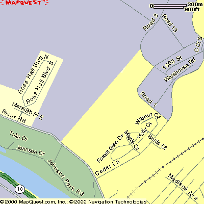
On River Road turn right on Cedar Lane, make left on Rd. 1 and another left on Rd. 13.
Route 22 West to Route 202 South (Flemington).
Proceed approximately 10 miles on Route 202 South to the Flemington traffic circle (first circle you come to).
At the circle, go 1/2 way around circle and exit out of circle onto Route 12 West.
Proceed 1/2 way through the next traffic circle and exit staying on Route 12 West.
At the next traffic circle proceed 3/4 way around circle and exit onto Route 523 South (Stockton).
Proceed approx. 1.5 miles to Lenape Park on your left.
To reach Fields #2, #3 and #4 make the first right after you enter the park.
Field #7 is at the end of the main road on the left. To get to Field #6 make a right at the end of the main road and follow to end. Field #6 is adjacent to the playground.
Take 18 South from New Brunswick/ the Turnpike, and follow for about 5 miles. Pass the mall on the right and turn right onto Rues Lane, directly past the Olive Garden Restaurant. Follow Rues Lane for about 150 meters and turn right into the Vo-Tech High School. Go all the way around the school and look for the fields in the back.